|
La Estrella Reserve
|
||||||||||||||||||||
 |
||||||||||||||||||||
|
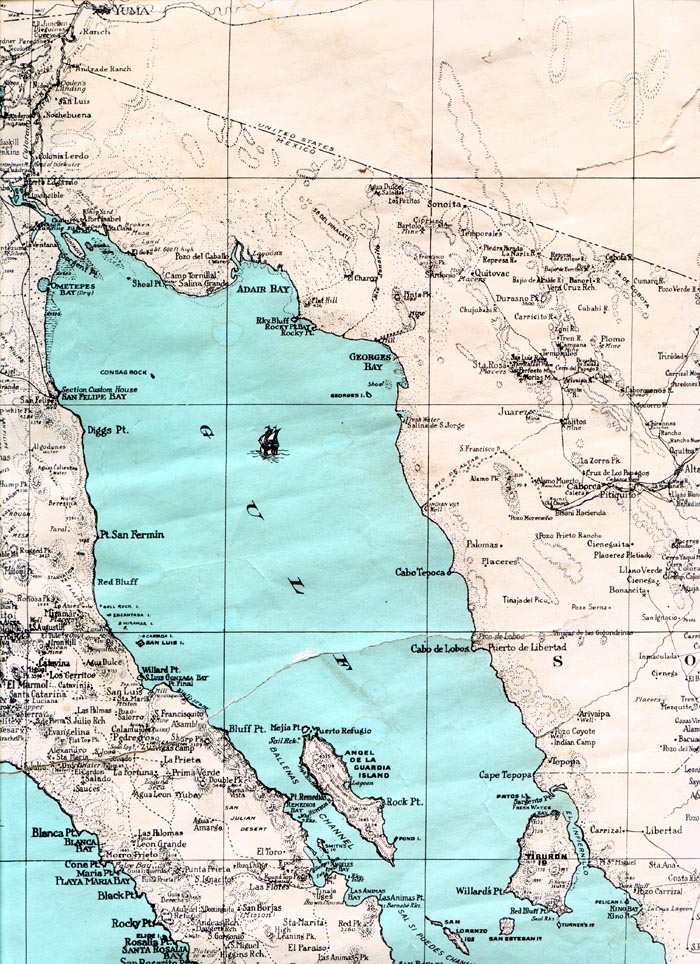
The first area being managed by the SDCC, known as La Estrella, is located on the coast of the Gulf of California roughly 110km directly west of Caborca, Sonora. La Estrella is a 272ha (672acre) parcel of land situated exactly in between the coastal towns of Puerto Lobos and Puerto Penasco, and is the center of the longest stretch of continuous sandy shoreline, of the Northern Gulf of California. The site is roughly 25km north of the fishing village Desemboque. "Desemboque", in Spanish, means "river mouth", and refers to the fact that the Rio Concepcion used to mouth out into the Gulf of California at this site. The delta of this river formerly extended northwards and onto La Estrella. The map bellow illustrates how the watershed of the Rio Concepcion drains virtually all of northwestern Sonora, and is the second largest river that historically flowed into the northern Gulf of California (the Colorado River being the largest) (Minkley 1973, Brown 1994). Please note the location of La Estrella is identified as a delta, similar to the Colorado River delta. |
||||||||||||||||||||
 |
||||||||||||||||||||
|
The vast underground aquifer of the Rio Concepcíon fostered extensive agricultural and urban development of the desert coastal plain of northwestern Sonora, during the late 1940's. The result was an ever-lowering water table causing an increase in the cost of water extraction, and salinization of the aquifer in some coastal areas. Consequently, the economy floundered, and the costs of this non-sustainable use of water were high on the local community. The costs on the ecological community of the Rio Concepcíon were devastating. The surface flow of the river has been reduced to such an extent, that the river bed is a dry wash from the town of Caborca, to the Gulf of California. Extensive riparian forests of tropical-subtropical assemblages of willow (Salix gooddingii), cottonwood (Populus fremontii), and honey mesquite (Prosopis glandulosa) have all but disappeared with the river. Scattered cultivated trees at private ranches and along concrete irrigation ditches are all that remain of the immense gallery forest of the Rio Concepcíon. Similar cottonwood-willow forests are still found as isolated fragments along the headwaters of the Rio Concepcíon, such as in the vicinity of Nogales, and Sycamore Canyon. These forests are within the Arizona Upland subdivision of the Sonoran Desert (Shreve 1951, Brown and Lowe 1980), and have warm-temperate floral and faunal associations which differ to the tropical-subtropical associations found along the gallery forests of rivers at lower elevations (Brown 1994), such as the Rio Concepcíon between the towns of Caborca and La Estrella. The lush delta of the Rio Concepcíon, described by the Jesuit missionary and explorer Padre Eusebio Kino (1701), no longer exists. In contrast, the delta is now a large tidal sand flat, resembling the equally vanquished delta of the Colorado River, yet at a smaller scale. the impact from the lack of nutrients and freshwater inflow into the northern Gulf of California from both of these rivers has been extensive, and poorly assessed. The largest Sciaenid (croaker) of the world, the totoaba (Totoaba macdonaldi), used positive estuarine deltas (i.e. with freshwater inflow) within the northern Gulf of California as spawning and nursery grounds. This huge fish that once supported a large fishery (Felger and Moser 1985) is now endangered with extinction. (See Current Events for details on the illegal trade of totoaba in Tucson, Arizona). |
||||||||||||||||||||
 |
||||||||||||||||||||
|
The sand flats along the coast of La Estrella experience some of the largest tidal fluctuations in the world, with a vertical displacement of 9m (Thomson 2001). The low gradient of the sand flats, coupled with the large tidal displacement, results in an extensive intertidal zone. During extreme low tides, one may take up to an hour walking from the high tide line, to the low tide. As the tide recedes, large tidal lagoons are formed (>50m in length) which entrap a diverse, and poorly studied, assemblage of sand/soft bottom community of predominately juvenile fish. The low tide also exposes a series of sandstone rock outcrops, which provide a tidepool habitat for invertebrate and fish assemblages associated with rocky/reef substrates. Below are marine biology students sampling intertidal invertebrates. (see Research).
|
||||||||||||||||||||
  |
||||||||||||||||||||
|
Bordering the sandy coast of La Estrella, are large stationary dune formations (>80m), which harbor unique floral and faunal assemblages. The sand dunes of La Estrella are a part of the continuous stretch of dunes found along the coast from Estero Morura (south of Puerto Peñasco), to Puerto Lobos. The dunes are locally known as "barra los tanques", which refers to the fact that small artesian upwellings expose ground water within deep depressions in the dunes to create small widely scattered pools. One of these pools is located about 5km north of La Estrella. These small freshwater oases serve as refugia for remnant plant populations of original delta flora (Ezcurra et al. 1988). The view bellow is from on top of the dunes, where one can see the entire 272ha of La Estrella.
|
||||||||||||||||||||
 |
||||||||||||||||||||
|
Clearly visible, are the extensive honey mesquite (Prosopis glandulosa) "bosques" (Spanish for forests). These bosques create finger-like strips of growth, characteristics of deltas. In between the mesquite bosques are large expanses of alluvial clay and silt, known as "playas" (Spanish for beaches). During infrequent rains the playa expanses become inundated, creating large (>100m) temporary lakes, which often last for more than three months, until they evaporate.
|
||||||||||||||||||||
 |
||||||||||||||||||||
|
It is during this period of inundation that La Estrella regains some wetland characteristics. A wide variety of water birds are attracted to these large ephemeral bodies of water, including the white-faced ibis (Plegadis chihi), which is regularly seen. The white-faced ibis has not been observed often in Sonora, especially along the shore (Russell and Manson 1998, record 4 single birds). This may reflect the loss of crucial wetland habitats for migratory stops along the coast such as the delta marshlands of the Rio Concepcíon. Although the surrounding bosque vegetation is typical of the Sonoran riparian scrubland (Brown 1994), emergent vegetation of marshlands and deltas appear such as cattail reeds (Typha sp.). The fact that rivers no longer flow into the northern Gulf of California makes such marshlands amongst the most endangered habitats of the Sonoran Desert. These marshlands are critical habitat for endangered fish such as the desert pupfish (Cyprinodon macularis), and the Gila topminnow (Poeciliopsis occidentalis), both of which have been virtually extirpated from Arizona (Minkley, 1973)
|
||||||||||||||||||||
|
||||||||||||||||||||